Mapping the Underground
One of my initial goals in understanding the Eureka Underground turned out to also be one of the most difficult - mapping the underground. The historic city marker about Mud Street describes underground passages "along Main and the downhill side of Spring Street". We can catch a glimpse of the lower level entrances of some of the buildings if the owner is so inclined to grant us entry into their basement. Most of these underground level facades are not very elaborate, leading one to believe that these lower levels were never used as proper storefronts, or that the corrosive nature of "Mud Street" was well known during construction. After all, decorative wooden ornamentation would only last as long as its paintjob if it was covered in wet mud for extended periods of time.
After speaking with several seasoned local explorers from the Underground Ozarks Forum, I've found some who believe that they have extensively explored Underground Eureka. In most cases, they've entered the underground by crawling into storm drains and have encountered lots of debris and water runoff, but most have never seen an underground storefront. This led me to believe that there was more than one system of tunnels in Eureka Springs.
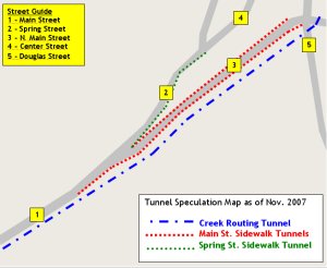
We have the underground areas below the sidewalks, where parts of Main and Spring Streets were said to have been raised. Most of these tunnels have been walled off at property lines, creating individual caverns that are only accessible via the adjacent building basements. We can call these the "sidewalk tunnels" for identification purposes. One can walk along Spring Street or Main and see glass blocks embedded in the sidewalk, purportedly placed to shed light on the hidden tunnels below. This older glass is said to have contained manganese, which turns a purple hue under the sun's rays.
The other (slightly) more accessible underground area of Eureka Springs is actually the storm drain system that feeds into the original creek routing tunnel. Most of the buildings and parking lots on the east side of Main Street straddle Leatherwood Creek. You can see it in some of the early Sanborn Insurance maps. This creek flows beneath the original basement level of most of the buildings. From early photographs, such as the Auditorium groundbreaking photo at the right, we can see a small square tunnel built for the creek to flow under the building. Local explorers have confirmed entry into a similar square tunnel while making their way through the storm drain system.
With more than one "underground" system of tunnels in downtown Eureka Springs, it is important to understand which set of passageways someone is referring to when they relate personal exploration experiences. Asking about old windows seems to be an effective way to discern between the two, since most of the tunnels below the sidewalks face building facades. The underground sidewalk tunnels of Main Street are more publicized and more commonly explored than their Spring Street counterparts, but much of the underground still remains a mystery.
« Back to Underground Eureka Homepage
Oiriginal Tunnel Speculation

Auditorium Groundbreaking Photo Detail (1928)

Is This the Same Creek Routing Tunnel?
Photo Courtesy of our friends on Underground Ozarks